There is one place in the U.S. where four states meet: Utah, Colorado, New Mexico and Arizona. This place is called the Four Corners. When you go there, you can stand in the four states at the same time;) Click on the picture to read when it was established:
 The Four Corners area used to belong to Mexico, from which it was acquired as a result of the 1848 American-Mexican war. Now the area belongs to the indigenous Navajo Nation and the Ute. You have to pay $3 to visit the place. The inscriptions under the names of the neighboring states suggest that it is a monument commemorating an agreement between the people inhabiting the area. The inscription goes as follows "Four States":
 "Here Meet"
 "In Freedom"
 "Under God"
 Here is what the Four Corners Monument looks like from a distance (the picture grows if you click on it):
 The trip to the Four Corners allowed me to set foot in New Mexico, whose capital is Santa Fe although, as I have written elsewhere, the biggest city is Albuquerque. New Mexico is known for the biggest population of Hispanics in all U.S. states (43%).
  The picture below was taken on the way to Monument Valley: note how the wind has carved blocks in the rock. I am already excited about what will come next;)
 On the road to Monument Valley - the view of Dead Horse Point State Park: the beautiful red mesas make you feel as if you were entering a fairy world. Click on the picture to see all the shades of red:
 Here is another breath-taking view of the wind's artistic ability to sculpt the soft rock and produce intricate shapes (click on the picture if you want):
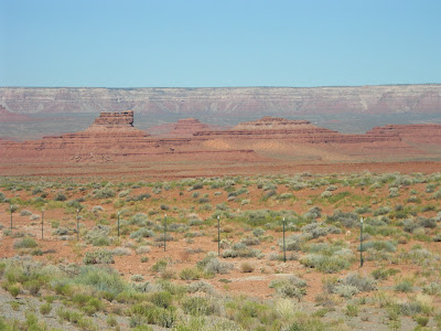 Below is the left-hand side of the previous view from a different perspective:
 Visible below is a nice meander of the San Juan River, which joins the Colorado River at Lake Powell.
 And here is a classic road view of Monument Valley. The Valley, which lies on the border of Utah and Arizona, belongs to the Navajo Nation Reservation and is part of the Colorado Plateau. It is famous for the sandstone buttes, that is tall hills with vertical sides and relatively flat tops - miniature mesas, one might say;) We're driving along US 163 and approaching the Valley from the north. Click on the picture - we have still quite a distance to cover to get there:
 We are approaching Monument Pass, slowly but successfully:
 Natural forces (wind and rain) have eroded the land and created the wonderful sandstone formations which seem to defy gravity:
 Below is another steep butte visible from the road leading now to the Painted Desert:
 The Painted Desert (click on the picture) is a beautifully colored vast area of badlands, which we passed on the way from Monument Valley to Grand Canyon. The name of the desert derives from its many colors:
 The Painted Desert wasn't on our itinerary, so we only drove by watching the area that looked like a multi-layered colored cake (clicking on the picture might help):
 And below is the last glimpse of the beautiful desert. We are turning left now to get to Grand Canyon's South Rim. This will come next on the blog.


